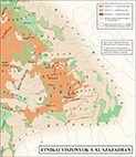
B29 - Ethnicity, C11
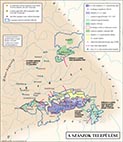
B30 - Saxons’ settling
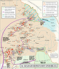
B31
- Romanian immigration
B32
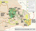
- Internal upheavals
Erdély történének atlasza (Historical Atlas of Transylvania)
Having been aware for long of the neglected nature of the mapping of the history of South-Eastern European lands, especially in comparison to that of more westerly areas, not least of no historical atlas having ever been dedicated to Transylvania, a country in its own right, even if with limitations for three centuries, I decided in 1988 to embark on the creation of an atlas dedicated to the mapping of its history. This was in Hungarian. I prepared the first six maps in black and white, but had to halt my progress due to the need of accepting commissioned tasks so as to earn a living. In the event the interruption proved to be much longer than I foresaw it. This nonetheless, had an advantage. Technology developing in the interim made the creation and production of colour maps cheaper and easier than previously. I reworked the existing maps accordingly, now on screen, and continued advancing in colour. It made sense to change my approach in another way too later, when deciding to move planned to be at first just short texts appearing directly on the maps to accompanying pages next to them. Thus each spread of the atlas consists of a textual and a map page. This proved to be the final form. With more inevitable interruptions, I completed the atlas as late as 2010. Work spent with it was I estimate about six years or nearly so. It was published by Méry Ratio in 2011 in 103 map plates, and a colour timeline plate. With text, all in all in 224 pages.
Click on any map to see it enlarged.
|
|
|
|
|
|
B29 - Ethnicity, C11 |
B30 - Saxons’ settling |
B31
- Romanian immigration
|
B32
- Internal upheavals
|